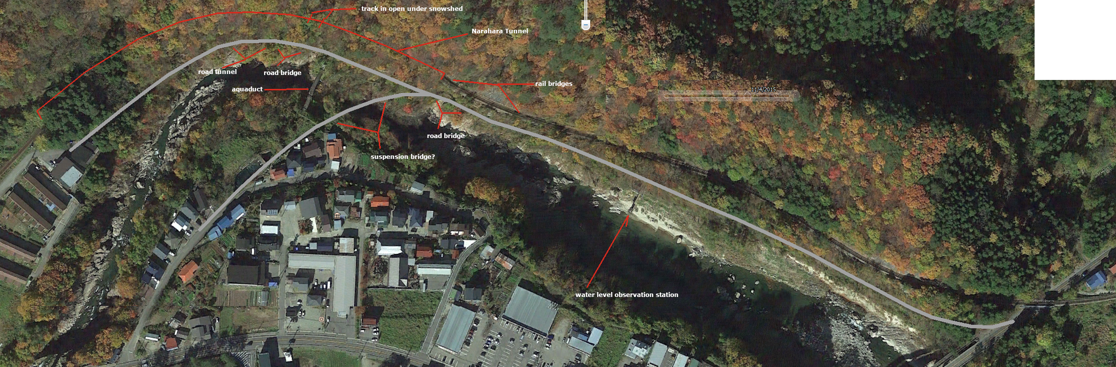
Heading towards Narahara from Yagoshima, the rail line passes through the village of Nishiura, where it passes over a bridge above NH121 and turns westwards. This westwards section between the overpass and the Narahara Tunnel is one of the most famous and photogenic spots on the line, with the railway running over a pair of short bridges tucked right up against the cliff face before entering the tunnel at a scenic spot called Hitoiwa. These bridges are of plate girder construction, hardly wider than the track itself. The section with these bridges begins just after the water level observation post on the river.
Running parallel to the rail line was the old road (now closed and mostly overgrown). The old road began right where the present NH121 road bridge (the Wakamizu Bridge) begins; the Wakamizu Bridge was, as far as I can gather, built in 1959, but the old road remained in use for some time after that. The road followed the railway closely, about 10 m lower than the rail line, and there was a short bridge at the same location as the second of the cliff-face rail bridges right before the tunnel entrance.
Shortly after the railway entered the tunnel, the road forked, with the fork crossing a suspension bridge across the river; the towers of this bridge are still in place, but the bridge itself is gone. The main road continued on parallel to the rail line, passing by an aqueduct-bridge, part of an underground pipeline carrying water to a power station a few kilometres away; this power station supplied electricity to a Shōwa Denkō facility at Kitakata, about 40 km away. This pipeline is still in use. Immediately after the aquaduct-bridge there was a half-bridge for the road, a concrete retaining wall on the river side of the cliff supporting the road. The road then entered a short tunnel.
Just above the spot where the road crossed the retaining wall and entered the tunnel, the rail line emerged from the tunnel for a very short distance before entering another tunnel; this "gap" in the tunnel is covered by a snow shed.
The Narahara Tunnel was the last tunnel on the Aizu Line when heading towards Aizu-Takinohara.
弥五島から楢原に向かって走って線路は西浦の村を通過する、ここで線路は跨線橋にて国道121号を渡るその後西向きに回れ以降に続ける。この跨線橋と楢原トンネル間の西向きに走っての線路部分は会津線の最も有名なと絵のような場所の一つである。比戸岩の景勝地にて線路は崖に向かって押し上げての短い橋梁の二本を渡れトンネルに入る。これらのプレートガーダー製の橋梁はかろうじて線路より広い。跨線橋の後での一番目橋梁は川での水位観測所のすぐ向こうにて始まる。
鉄道線路の平行に走って今閉鎖されてそして主に生い茂ったの古い道路があった。古い道路は現在の国道121号の道路橋(「若水橋」)の出発点から始まった。私の知る限りによる若水橋が1959年で建てられたがその後しばらくの間で古い道路が使用中で残られた。道路は鉄道に密接に沿って走った、線路よりざっと10m低いであった。トンネル口の真正面で崖の顔にての二番目の鉄道橋梁と同じ場所にて短い道路橋があった。
鉄道線路がトンネルに進入の直後に道路は別れられた、枝道は川に架かる吊り橋を渡った。この吊り橋の塔たち未だに存在するが橋自体はなくなった。鉄道線路の平行に引き続いて本街道は水道橋を通り過ぎた。この水道橋は数キロ先の発電所へ水を輸送しての地下のパイプラインの一部である。この発電所は喜多方にあるの(約40㎞先)昭和電工の施設へ電気を補給している。このパイプラインは未だに使用中である。水道橋の直後で道路のために半橋があった、崖の川側にてコンクリート製の擁壁は道路を支えた。その後道路は短いトンネルに進入した。
道路での擁壁の真上鉄道線路は非常に短い距離にトンネルから出た、その後別のトンネルに進入していた。トンネルにてのこの空隙はスノーシェッドで覆われている。
会津滝ノ原に向かって走って楢原トンネルは会津線の最後のトンネルである。